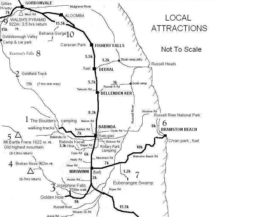
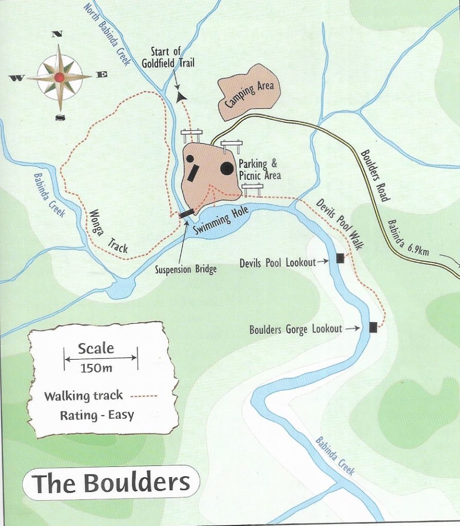
1. THE BOULDERS
NATIONAL PARK: Dogs not allowed
DISTANCE: 1.2km
TRACK CLASS: sealed, undulating path, boardwalks, platform viewing, wheelchair accessible
DIFFICULTY: moderate to easy
TIME: 30 minutes
TYPE OF WALK: return – 3 lookouts
FACILITIES: in the park – toilets, cold showers, gas BBQs, sheltered shed, picnic tables, grassy area
WHERE: approx 6km from Babinda township.
NEEDS: good walking footwear, hat, sunscreen, camera
SAFETY: WARNINGS: Stay within signed railings at lookout areas – extreme danger – drownings have occurred.
HEED ALL WARNING SIGNS
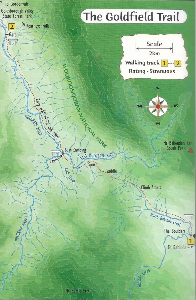
2. THE GOLDFIELD TRACK
NATIONAL PARK: Dogs not allowed
DISTANCE: 20km
TRACK CLASS: earthen and rocky surface, creek and river crossings, steep in places.
DIFFICULTY: moderate to hard
TIME: 7 – 9 hours
TYPE OF TRACK: one way – car drop off at Babinda Boulders or camp on the way
NO FACILITIES
NEEDS: protective clothing, good walking footwear, insect repellent, full camping equipment if camping on the way, water, food, camera
WHERE: direction sign starts from Babinda Boulders.
SAFETY: Always check trail conditions for closures and weather conditions before planning a trip.
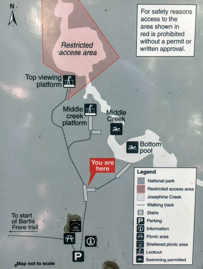
3. JOSEPHINE FALLS
NATIONAL PARK: Dogs not allowed
DISTANCE: 1.4km
TRACK CLASS: Sealed path, wheelchair accessible to top pool viewing platform, steps to swimming areas
DIFFICULTY: Easy
TIME: 1 hour
TYPE OF WALK: Return
FACILITIES: toilets, picnic sheltered shed and tables
NEEDS: Camera
WHERE: 8km from Bruce Highway into Price Road and follow signs to Josephine Falls.
SAFETY: creek susceptible to flash flooding.
TAKE HEED OF ALL WARNING SIGNS
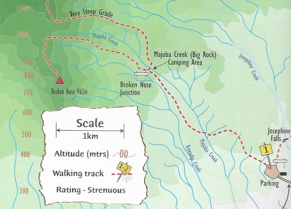
4. BROKEN NOSE
NATIONAL PARK: dogs not allowed
DISTANCE: 8km
TRACK CLASS: earthen, rocky, rough surfaces, rock scrambling & climbing, extremely steep, variable weather conditions, Recommended for experienced hikers
DIFFICULTY: hard,strenuous
TYPE OF WALK: Return
TIME: 6 hours
WHERE: Track starts at Josephine Falls
NO FACILITIES ON WALK
NEEDS: good walking footwear & hat, protective clothing, insect repellent, water & food, camera.
SAFETY: Refer to information below
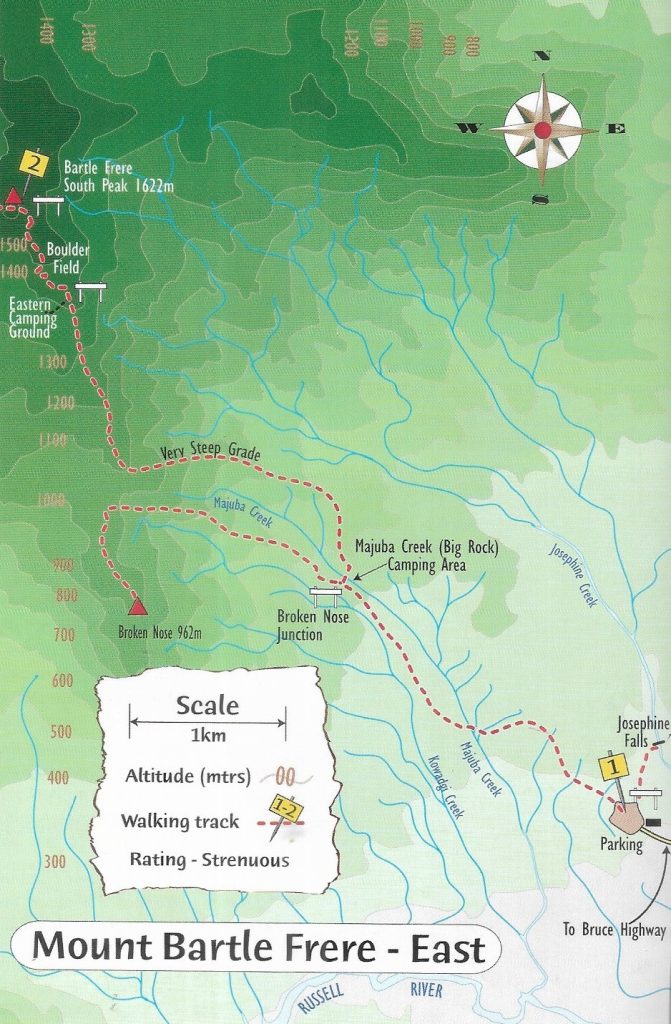
5. MT BARTLE FRERE EAST
NATIONAL PARK: dogs not allowed
DISTANCE: 15km
TRACK CLASS: earthen, rocky, rough surfaces, rock scrambling & climbing, extremely steep, variable weather conditions, Recommended for experienced hikers
DIFFICULTY: hard and strenuous
TIME: 12 hours
TYPE OF WALK: recommended 2 days
NO FACILITIES
WHERE: track begins at Josephine Falls
NEEDS: good walking footwear & hat, protective clothing, insect repellent, water & food, full camping gear, camera:
SAFETY: Refer to information below
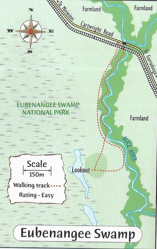
6. EUBENANGEE WETLANDS
NATIONAL PARK: dogs not allowed
DISTANCE: 1.5km
TRACK CLASS: rainforest, grass and slight hill to lookout
DIFFICULTY: easy
TIME: 1 hour
TYPE OF TRACK: return
NO FACILITIES
NEEDS: protective clothing and hat, insect repellent, sunscreen, water, binoculars camera
WHERE: 9km from the Bruce Highway, Mirriwinni, to turn off at Cartwright Road then 2km to carpark.
SAFETY: Always check track conditions for closures
WARNING CROCODILE SIGNS – Visits not recommended during flooding as crocodiles move into flooded track areas like the tracks.
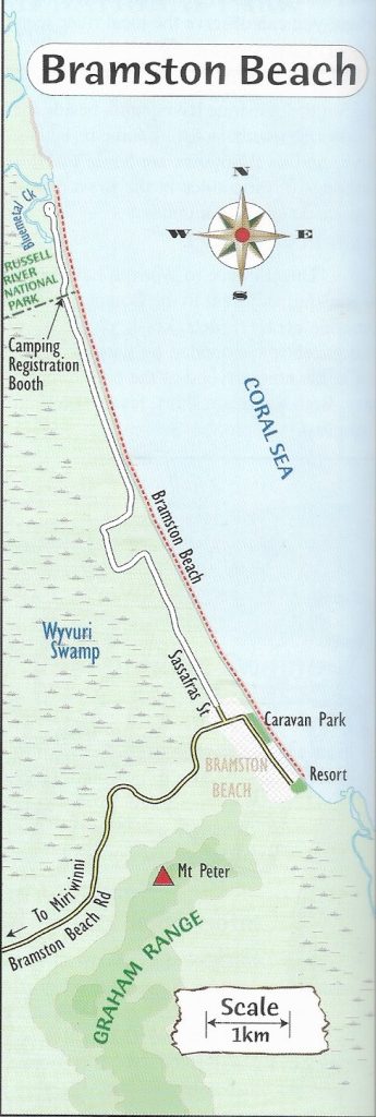
NATIONAL PARK: dogs not allowed
DISTANCE: 7.5km
TRACK CLASS: beach walking on coarse sand
DIFFICULTY: easy
TIME: 2 hours
TYPE OF TRACK: one way
NO FACILITIES
NEEDS: sunscreen, water, insect repellent, camera, full camping gear and must self-sufficient if staying in the National Park camping area, permit required to stay in one of the 5 campsites, fees apply.
WHERE: 17km from the Bruce Highway, Mirriwinni, to turn off at Sassafras Street, Bramston Beach. Follow gravel road 5.5km to National Park sign, 1.5km to car park.
SAFETY: Check trail conditions for closures and weather conditions.
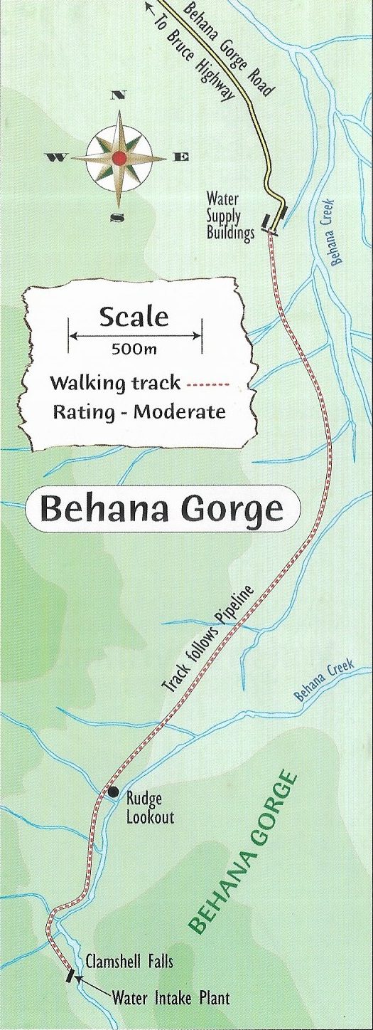
8. BEHANA GORGE
NATIONAL PARK: dogs not allowed
DISTANCE: 3.2km
TRACK CLASS: sealed surface, steep in parts
DIFFICULTY: easy to moderate
TIME: 1 hour
TYPE OF TRACK: return
NO FACILITIES
NEEDS: protective clothing, good walking footwear, insect repellent, water, camera
WHERE: 4.6km from Bruce Highway into Behana Gorge Road.
SAFETY: Check trail conditions for closures and weather conditions.
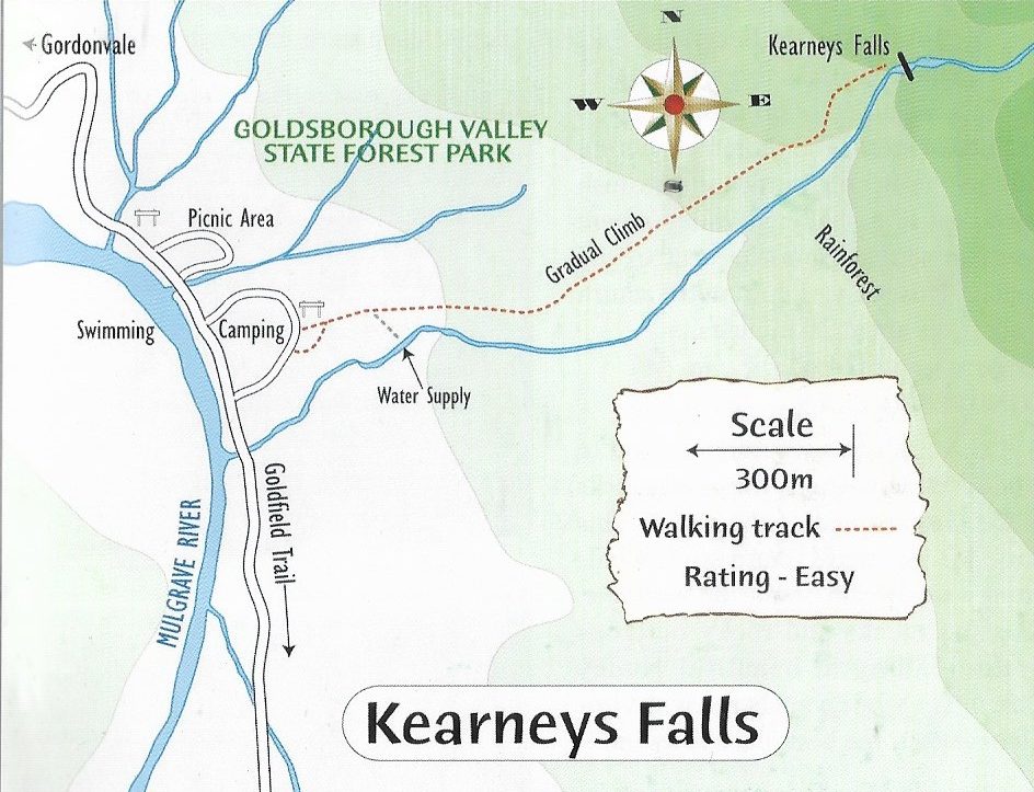
9. KEARNEY FALLS
NATIONAL PARK: dogs not allowed
DISTANCE: 1.7km
TRACK CLASS: rocky surface, stone steps, rainforest
DIFFICULTY: moderately graded
TIME: 40mins
TYPE OF TRACK: return
NO FACILITIES
NEEDS: protective clothing and hat, insect repellent, water, camera
WHERE: from Gordonvale 6.5km along Gillies Highway road, left at Goldsborough Road, 12km to the day use area.
SAFETY: Check trail conditions for closures and weather conditions
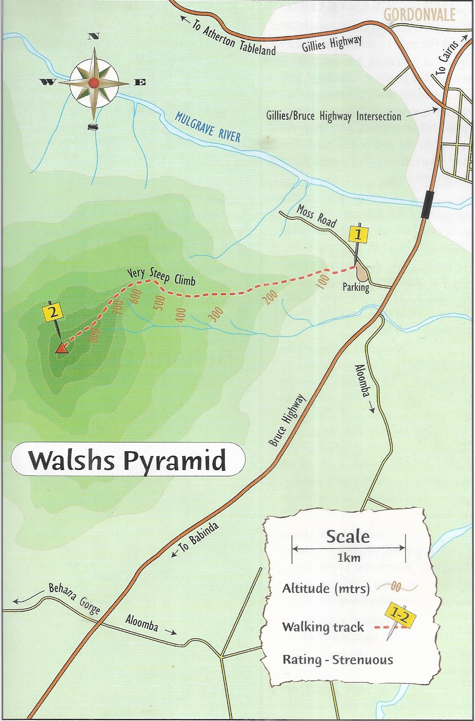
10. WALSH’S PYRAMID
NATIONAL PARK: dogs not allowed
DISTANCE: 7km
TRACK CLASS: earthen and rough rocky surface
DIFFICULTY: hard to very hard, steep to very steep, recommend an early morning start
TIME: 3-4 hours
TYPE OF TRACK: return
NO FACILITIES
NEEDS: protective clothing and hat, good walking footwear, water, food, camera
WHERE: turn off Bruce Highway into Moss Road, south of Gordonvale.
SAFETY: Check trail conditions for closures and weather conditions.
FOR BARTLE FRERE EAST AND BROKEN NOSE WALKS
SAFETY:
*be fit and experienced to undertake this hike.
*have the correct maps and a compass.
*have adequate food and water.
*bring full camping gear
*bring clothing for extremely cold and wet weather.
*bring a fuel stove (no fires are permitted).
*give trip details to a responsible person.
ALWAYS CHECK WEATHER CONDITION
REGISTER WITH QUEENSLAND NATIONAL PARK